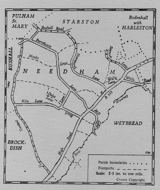
In earlier days footpaths would be used mainly by farmworkers, postmen, churchgoers and schoolchildren. Not all of the footpaths are usable now but they are as follows:
- High Road (near house147), Luck’s Mill Lane, for river & Weybread
- High Road (by Mayland) to river & weir
- High Road (opposite Brook Lane) to Mill Lane
- High Road (by Village Hall) to Burnthouse Lane - between “Four Gates” and Brook Lane
- High Road (at Wellsgate) to Harman’s Lane - once a cart track. This path is “Wells Lane”.
- High Road (opposite Gunshaw Hall drive) to Wells Road; somehow known as “The Promised Land”.
- “Monks’ Lane”: Harman’s Lane via Skeetsmere Cottage (this stretch is partly a watercourse since the great flood of 1912) to Tumbril Lane opposite Hogsty Lane (this stretch mainly ploughed up in about 1970)
- Burnthouse Lane (at Skeetsmere House) to Starston Lane crossing Harman’s Lane
- “Doles Lane”: Tumbril Lane via Doles Farm to junction on of Brook Lane and Kiln Lane (now partly a watercourse at southern end). A branch of this path - in use- emerges near Brabbin’s pond in Brook Lane (signposted)
- Branching off Wells Lane to Starston Lane
- Starston Lane to Gunshaw Hall and Harleston Common
- Wells Road (by parish boundary) to river
I wonder how many of these footpaths are in existence now?- Ed
Accessibility of footpaths is often raised at Parish Council meetings. If you are aware of footpaths that you would like to use but are becoming impassable the PC will arrange for the Council Rangers to clear the way.
No comments:
Post a Comment